
“Spokane’s streets are dangerous!”
That sentiment is thrown around nearly every Monday night at council meetings — and it’s true. Spokane’s streets are dangerous, but not necessarily in the way that public commenters mean. Yes, the city is in a state of emergency due to the opioid crisis, but property crime and violent crime rates in the city are way down, and arrests for camping violations are way up. You could make the argument that Spokane’s streets are actually the safest they’ve been in years … if it weren’t for our city’s collision rate.
The streets of Spokane are *literally* dangerous: it’s riskier to drive, walk or cycle on them than it is in other similarly sized cities, like Tacoma.
After a few particularly deadly months for traffic fatalities and outcry from both community groups like Spokane Reimagined and most neighborhood councils across the city, traffic safety has been one of the city’s most pressing issues.
Earlier this year, Mayor Lisa Brown signed an executive order committing the city to immediate traffic safety measures, after prominent community member Janet Mann was killed in a fatal traffic collision while crossing a street downtown, and the Spokane City Council passed their own resolution calling for budget-friendly fixes that could be done on the double.
For the past few months, RANGE has been working to understand the crisis through our coverage (and look at the transit-minded solutions proposed to mitigate it — better public transit, adaptive design strategies, pedestrian and bicyclist friendly networks.)
Data about collisions is one thing, but actually taking a look at the road infrastructure in Spokane that creates the most crashes is another. So, RANGE’s Urbanism columnist Lauren Pangborn and City Hall reporter Erin Sellers are going to take you on a guided virtual tour of the city’s Top 10 Most Dangerous Intersections so you too can get a sense for the safety of our city’s streets.
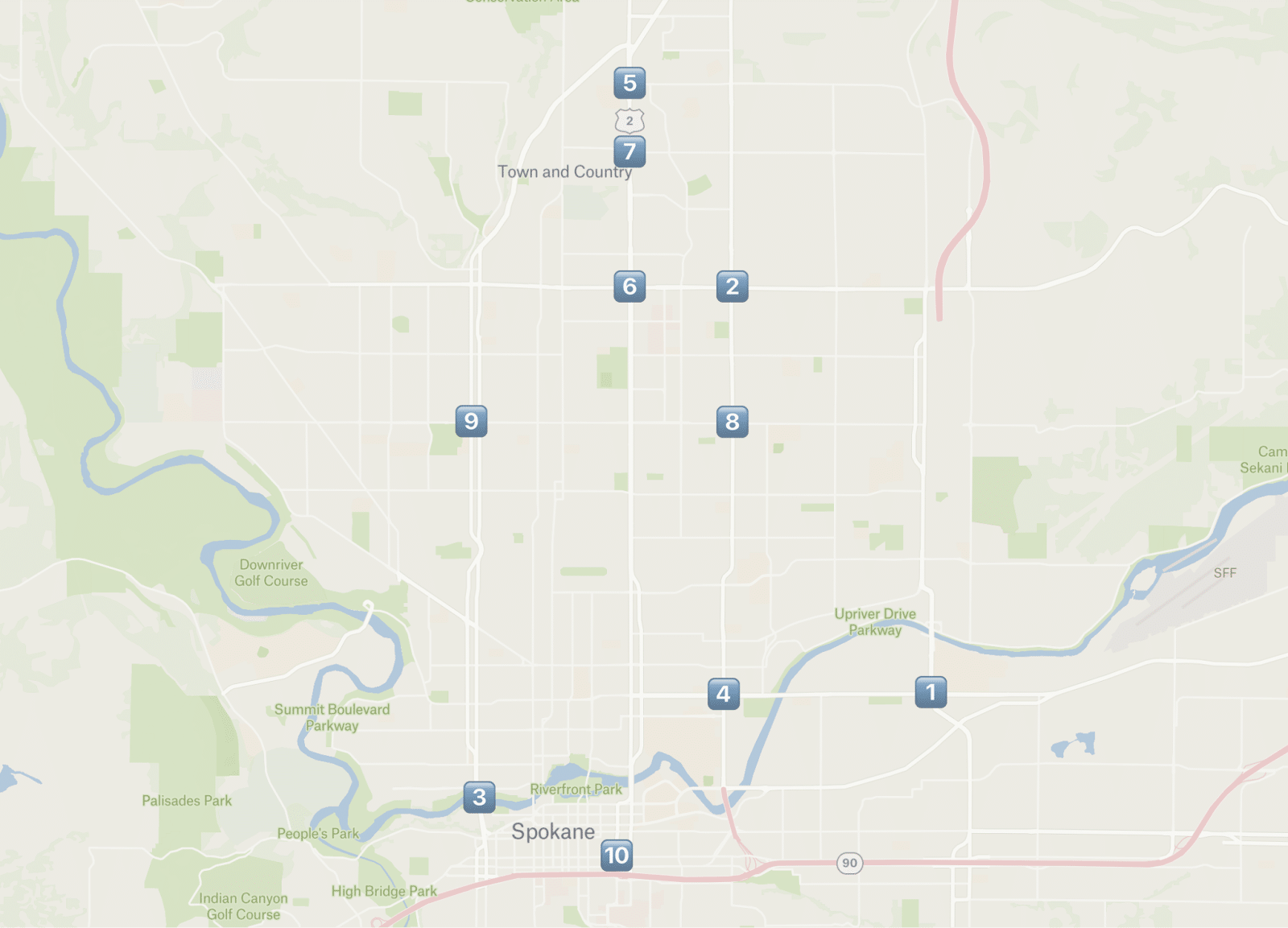
The Top 10 tour
Buckle up, folks: today, we’re taking a tour of the 10 locations in Spokane that have seen the highest number of collisions over the last seven years, and you’re definitely going to want to keep your arms and legs inside the vehicle.
10 fast facts on the 10 dangerous intersections:
- Three of the intersections on this list play host to coffee shop drive-thrus — two Dutch Bros and one Blissful Blends (owned by the same woman who owns the bikini barista coffee chain). Another has a Taco Johns, and two more are *near* drive-thrus that could back up into the intersection. This puts Spokane squarely into the nationwide trend of drive-thrus creating deadly traffic congestion.
- Four intersections are five lanes of traffic wide on both intersecting streets.
- One of the intersections isn’t actually an intersection, but an entire bridge (and a bridge with a blind merge and a persistent speeding problem).
- Three are in population centers with lots of pedestrians: a college and transit center, a high school and another college.
- Three are next to grocery stores — scary for the ambitious among us who walk to buy groceries.
- Half of the intersections have gas stations turn-ins. Two intersections have two gas stations.
- Seven are on major Spokane Transit Authority (STA) routes, which see pedestrian traffic: 83% percent of STA riders walk to their stops.
- Three could soon receive major Division Bus Rapid Transit line stops, which will likely increase in vulnerable road users (those on foot, on bikes and on mobility devices) and decrease in car traffic because Division BRT is being completed in tandem with the North-South Freeway.
- Seven are north of the river and none are on the South Hill (Spokane City Council Member Jonathan Bingle had a message for people driving in his district, “Maybe pay attention when you’re driving a little bit more.”)
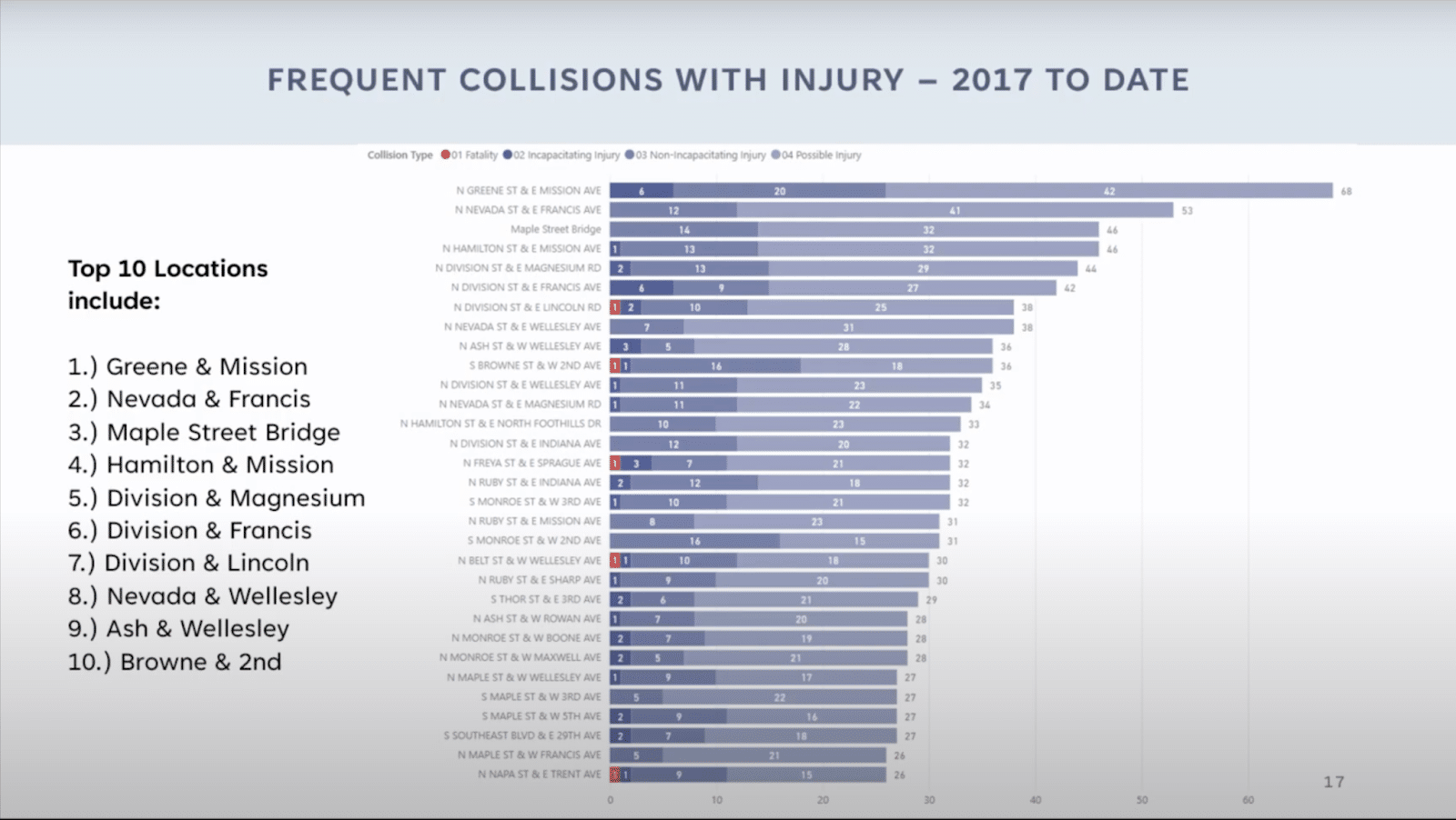
- Washington State Department of Transportation (WSDOT) has recorded 134 total traffic collision fatalities in Spokane over the last seven years. Only five of those fatalities have been at the most dangerous intersections, which means while you’re more likely to get into a crash at these intersections, traffic fatalities are more randomly spread across the city.
1. Greene Street & Mission Avenue - Council District 1
The most dangerous intersection in Spokane has seen 68 injuries in crashes since 2017, including 12 in just the past year. It consists of five lanes on Greene Street and five on Mission Avenue, both of which have 35 mph speed limits (but it’s probably quite tempting to speed descending northbound on Greene from the Freya bridge over the railroad).
The elevated North Spokane Corridor will run almost directly over this intersection in the coming years. One might assume traffic volumes and therefore crash frequency will decline once the freeway opens, but it’s been shown that traffic volumes will likely return to their pre-freeway levels within a year or two.
This intersection is adjacent to Spokane Community College and an STA transit center, both areas with heightened pedestrian activity. The Children of the Sun Trail will also run above this area. Millwood Trail, which will start at the north end of the college and run east, is set to be constructed by 2027. Both projects could bring even more pedestrian and bike traffic to the area. Dangerous intersections for those in cars make for even more dangerous intersections for those on foot or on a bike.
The city has considered installing a red light camera here, but it’s not clear when or if that is happening.
2. Nevada Street & Francis Avenue - Nevada/Lidgerwood neighborhood, Council District 1
This intersection, where 53 people have been injured in car crashes since 2017, also consists of five lanes meeting five lanes. It’s reasonable to hope that folks who live just south of Francis Avenue could walk or ride safely to the Albertsons or Harbor Freight Tools, but it’s tough to imagine feeling safe making that journey through this intersection.
STA route 28, one of STA’s higher ridership routes, and route 35 run through this intersection. The northbound 28 bus stop suffers from very little space in the area being dedicated to people rather than cars – the sidewalk is narrow so one is forced to stand closely to loud and polluting car traffic.
The intersection features a drive-thru coffee stand. Drive-thrus can be tough on both pedestrian safety and driver safety, and discourage walking and community connection.
3. Maple Street Bridge - Council District 3
46 people have been injured on the bridge since 2017.
Spokane Police Department Chief Kevin Hall said when he presented this data at a Spokane City Council committee meeting that speed is the most common contributing factor to the crashes at these 10 locations. The city appears to have known that speed is an issue on the bridge – there has been a permanent radar speed sign telling you just how fast you’re going perched on the north bank for years. Obviously the bridge has no signalized intersections on it, so the crashes here are not the result of red light runners (as one might expect from the other intersections on this list).
The entrance to the bridge from Riverside Avenue could be a factor. It’s basically a blind merge with little run-up and a median barrier blocking your view. And, with people persistently speeding over the bridge, it’s tricky to get up to the actual speed of traffic and merge safely.
Thankfully, conflicts with pedestrians are mostly absent from the bridge.
4. Hamilton Street & Mission Avenue - Council District 1
This intersection, where 46 people have been injured, also features five lanes crossing five lanes. (Don’t tell me you’re noticing a pattern 👀)
Gonzaga student housing in the area most likely means more pedestrian and bike traffic than an average neighborhood (have you seen the Game Day craziness around campus?), which makes these statistics especially scary. There are also two bikeways that cross Mission Avenue within mere blocks of this intersection: the Cincinnati Greenway and the Centennial Trail. It’s important that areas around bikeways are safe enough that users can comfortably reach said bikeways.
As with #2, ideally residents in the area could safely cross this intersection to reach the grocery store (Safeway, in this case). The city of Spokane’s study on how to make this neighborhood more walkable and vibrant identified Hamilton Street as a major barrier to circulation.
Also like other intersections on this list, its a transit hub, with the City Line running down Mission. It's also a transfer point to Route 28 and a transfer point for North Central High students who are traveling in from Chief Garry (as Discord user Captain_Phil pointed out).
There is a red light camera at this intersection, meaning the city has deemed it an intersection requiring intervention, and it issued 1,657 citations in 2023 alone.
Note from Erin: Literally a month ago, one of my friends got in a seven car pile-up crash here after an elderly woman *spoiler alert* ran a red light. This intersection is no joke.
5. Division Street & Magnesium Road - Council District 1
44 people have been injured at this intersection, where the massive seven-lane-wide Division Street meets three-lane-wide Magnesium Road. And like #2, it sports a drive-thru coffee stand.
The STA route 25 stop just south of this intersection is the 4th most used stop on the route, which sees nearly 1 million rides per year. It’s a stop STA has chosen to invest in: it has a large waiting area and even sheltered seating. Despite this area following auto-centric development patterns, it still sees plenty of pedestrian traffic.
This area will have “Tier 1” stops for the Bus Rapid Transit line – 50- and 60-foot stops with amenities and connections to bike lanes on both Magnesium Road and Price Road. The number of people walking and biking in the area will likely increase with the development of the BRT line in 2030.
A note about Division Street as a whole: the Division BRT line study found that “while bike and pedestrian related crashes accounted for 5% of total crashes, they accounted for 61% of severe injury and fatal crashes along Division Street.” Three of the top 10 and eight of the top 30 of the most dangerous intersections in Spokane lie on Division Street.
6. Division Street & Francis Avenue - boundary line of Council Districts 1 & 3
Both Division Street and Francis Avenue have six lanes at this intersection, where 42 people have been injured since 2017 – seven in the past year alone. And before that, a truly tragic six pedestrian fatalities between 2001 and 2008 made the stretch between Lyons Avenue and Joseph Avenue the 17th most dangerous street in the United States for pedestrians.
One might assume that transporting as many people as Division Street and Francis Avenue do will naturally result in this many injuries and fatalities, but US cities are outliers – cities around the world transport more humans than these two streets do, and do it more safely.
New bougie Tier 1 stops for the Bus Rapid Transit line are also planned for this intersection, so vulnerable user traffic could increase as the BRT is built.
This intersection features red light cameras, which caught an astounding 176 drivers running a red light in *September 2024 alone* and 2,907 in the entirety of 2023.
7. Division Street & Lincoln Road - Town and Country neighborhood, Council District 1
Like one of the three Division Street intersections on the tour, this Division Street intersection is seven lanes wide where it meets three-lane-wide Lincoln Road. One person has died here and 38 have been injured.
And like #2 and #4, there’s a grocery store here that serves the surrounding neighborhood. The high-traffic danger of Division Street remains a barrier to accessing it on foot or by bike.
The BRT study recommends major 60-foot-long stops here, in addition to new bike lanes east of the intersection to allow connection to the stops. And the county plans to build bike lanes west of this intersection in 2025.
8. Nevada Street & Wellesley Avenue - Council District 1
Unsurprisingly and unfortunately, both Nevada Street and Wellesley Avenue have five lanes at this intersection. And 38 people have been injured here in crashes since 2017.
It’s also the meeting and transfer point of two of STA’s highest ridership routes: 28 and 33. And the teenagers in this area attend Rogers High School, which is only two blocks away.
STA hopes to convert route 33 into a High Performance Transit line, with enhanced stations and amenities and more frequent transit. As with the Division BRT line, one could reasonably expect pedestrian and cyclist traffic to increase with transit investments.
9. Ash Street & Wellesley Avenue - Council District 3
It’s not clear what makes this intersection more dangerous than its sibling at Maple Avenue and Wellesley Avenue, or Ash Street and Francis Avenue, but whatever it is, it has caused 36 injuries. It’s also scary to have an intersection on this list directly adjacent to a school (Shadle Park High School, in this case).
Like #8, high-ridership route 33 runs through this intersection, where it meets route 23. The westbound 33 stop here is among its most used stops, so this area sees more pedestrians than one might guess.
This intersection also has a red light camera, and is just before the beginning of the 20-mph school speed limit zone on Ash. In 2023 alone, a whopping 1,300 citations were issued to cars running red lights at this intersection. What’s even crazier is that, of the 10 intersections that currently have red light cameras, this intersection logged the second least amount of citations — the highest was 3,535 at S Thor Street and E 2nd Ave.
10. Browne Street & Second Avenue - Council District 1
36 people have been injured here, and one has died.
Both Browne Street and Second Avenue are one-way streets here. Many North American cities, including Spokane, reoriented their downtown grid into one-way couplets when driving into downtown from the suburbs became common. But some cities have found that one-ways increase driving distance, are worse for businesses and are more dangerous for pedestrians. Five of the top 30 most dangerous intersections listed by Chief Hall are on one-ways downtown. Janet Mann was killed at Browne Street and Main Avenue, a similar intersection to this one.
The city is gearing up to build the Pacific Avenue Greenway just one block north of this intersection and a bike lane on Second Avenue just east of here, which like other projects we’ve listed here, may increase numbers of those on bikes in the area.
The End of the Road
Most of these 10 intersections have transit, pedestrian and bicycle infrastructure improvements coming in the next five years – for instance, Division Street will be reduced to five lanes when the BRT lanes are built. While those projects themselves may help decrease the design speed of these intersections, they will likely bring more vulnerable users to them as well.
While it’s true that the most common factor in all these collisions is speed, the easy answer of educating drivers about the dangers of speeding and asking them to slow down doesn’t seem to be working – it’s the same message that has come out of public health educational campaigns for decades, but collisions are still on the rise.
Rather than more educational campaigns, NACTO (one of the city’s sources for street design standards) recommends design changes: fewer lanes, narrower lanes, roundabouts, daylighting, protected bike lanes, street trees and other design elements to reduce street’s design speed – the speed at which it feels natural to drive.
As Spokane wrestles with balancing a budget deficit and community safety (in more ways than one), local urbanists have continued to push the city for cheap, innovative solutions like adaptive design strategies to decrease traffic congestion by getting people walking, biking or bussing to their destinations instead.
Council members have considered — and adopted — code changes to tackle traffic safety, like banning drive-thrus in specific high-traffic areas (does anyone know what’s going on with the potential South Hill Chick-fil-A that got caught in permit limbo?). They also recently adopted an ordinance that expanded both the list of places speed cameras could legally be placed and what the funds collected could be spent on (for more details, see page 490 of this agenda.)
Mayor Lisa Brown has spoken publicly about looking at speed limit reductions and potentially killing dangerous one-ways where drivers have a tendency to speed.
There are creative solutions available, too; studies have shown that asphalt art — like the rainbow intersection downtown that’s become something of a third rail at council meetings — actually slows drivers down, reducing accidents and reducing the fatality rate of accidents when they still occur.
And, there are simpler but more expensive fixes, like shilling out for lighted crosswalks and paying for more traffic enforcement time from the Spokane Police Department.
There’s no perfect solution to instantly fix Spokane’s dangerous streets (we all know how long construction takes) but here are a few ways you can get involved in the conversation and keep Spokane’s streets safer for everyone:
- Consider alternative modes of transportation, like bussing, biking or walking.
- If you’re driving, put your damn phone away and follow the speed limit.
- Be extra careful at these 10 intersections! Stay defensive, stay vigilant, stay careful.
- Make sure your elected officials know traffic safety is important to you! Spokane will be getting its very first Director of Transportation (and Sustainability) this spring, which is a good person to contact with feedback. Plus, you can always bother city council members, call the mayor or attend one of the many transportation-related boards and meetings we include in CIVICS each Monday.
And with that, we’ve reached our destination. If you enjoyed the tour, please let us know! You can direct questions, comments or feedback to us personally at erin@rangemedia.co or bikeroutehelp@rangemedia.co or join the conversation on Reddit, Bluesky or Twitter. Safe travels!
Edited to remove neighborhood tags (Google lied to us) and add some additional context about bus lines.


